
DeepScan AI Flags Underground Voids Before Roads Collapse

-
공유하기 선물하기


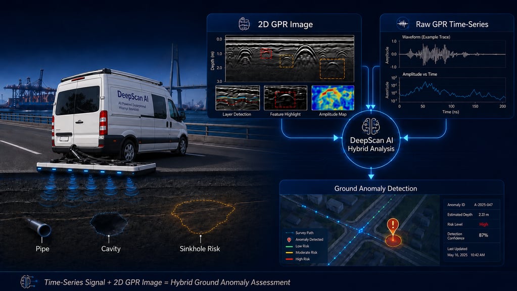
Multi-frequency radar feeds a dual-path AI model that maps subsurface anomalies to location, targeting 90% accuracy pending field validation
BUSAN, South Korea -- A South Korean technology company has built an underground inspection platform that reads ground-penetrating radar two ways at once. DeepScan AI, from SmartBank Co., Ltd., flags cavities and weakened soil before pavement, water mains or rail beds show damage.
Cavities Stay Invisible Until Pavement Gives Way
The American Society of Civil Engineers counted roughly 240,000 water main breaks a year in its 2025 Report Card for America's Infrastructure, at about $2.6 billion in annual repair and maintenance cost. Those breaks occur across more than 2 million miles of buried pipe run by close to 150,000 public water systems. The same report graded U.S. roads a D+.
ASCE puts the average service life of that pipe at just over 78 years as of 2023, six years shorter than its 2018 figure. A leaking main washes soil out from around itself. The ground above holds for weeks or months, then drops.
Crews reach most of these sites after the drop. The standard screening method asks a technician to read radar imagery by eye and judge what the reflections mean. Interpretation quality moves with the reader, and a subtle void reads much like a buried utility or a change in soil moisture.
Hybrid Analysis Reads Radar Timing and Image Shape
DeepScan AI sweeps a route with multi-frequency ground-penetrating radar and sends each return down two paths. One path reads the raw time-series signal, tracking how a reflection behaves from one moment to the next. The other reads the reconstructed subsurface image and its spatial shape. Anomaly candidates come from both readings together, and each one carries geographic coordinates so an operator can rank a corridor by risk instead of walking it end to end.
Its patent specification describes detection to roughly 7 meters (23 feet), varying with antenna frequency, soil composition and site conditions. SmartBank is also doubling the receiver from 4 channels to 8, widening lateral coverage on a single pass. The company sets analysis accuracy at 90% or better and false positives at 5% or lower, both stated as targets awaiting validation under defined ground and operating conditions rather than measured field results.
DeepScan AI targets municipalities, transportation and transit agencies, port and rail operators, airports, utilities and the inspection contractors those owners hire. Each of those owners inspects buried assets on a fixed schedule and a fixed budget, which is what a risk-ranked corridor is meant to change.
About SmartBank
SmartBank Co., Ltd. develops AI-based subsurface inspection technology for public infrastructure owners and the contractors that inspect buried assets on their behalf. Its DeepScan AI platform combines multi-frequency ground-penetrating radar with paired time-series and image analysis to locate underground anomalies and tie each finding to a mapped position, covering road, water, rail, port and airport corridors. Learn more at www.smartbank.ne.kr.
Media Contact
Myoung-Su, Ahn
anms@smartbank.ne.kr




![[AI시대, 교육의 미래] 학벌의 시대는 끝나는가](https://s3.ap-northeast-2.amazonaws.com/image.themiilk.com/production/reports/1a0013f3ee2/41650af65d_1786727875.png)